Plata
Yukon’s High-Grade Silver Opportunity
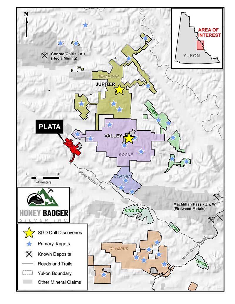
Yukon, Canada (165 km east of the past-producing Keno Hill Mine & 30 km west of Snowline Gold’s Rogue Project”)
A historic high-grade silver property with exceptional exploration potential, situated in the prolific Tombstone Gold Belt adjacent to Snowline Gold’s major Rogue gold discovery.

A Historic Producer with Modern Potential
The Plata Property is a historic producer of high-grade silver ore, having produced approximately 290,000 ounces of silver from small-scale mining of high-grade veins exposed at surface. Ore was mined and flown by fixed-wing aircraft to Idaho for processing.
Silver mineralization is believed to be associated with the Mayo and Tombstone intrusive suites in a similar geologic setting to Snowline Gold’s Rogue Project.
Key Highlights
- 290,000 ounces of silver historically produced
- Exploration has identified numerous mineralized zones hosting high-grade silver, gold, lead and zinc-bearing veins and stockworks.
- Adjacent to Snowline Gold’s Rogue gold discovery
- 10,156-hectares with recent claim additions
- Multiple new zones discovered in 2025
- High grade Copper, Antimony and Tungsten mineralization identified
Plata Project Highlights
Identified extensive high-grade antimony, copper, and tungsten mineralization at its 100%-owned Plata Project in Yukon, in addition to the project’s known silver and gold mineralization.
These critical minerals were historically overlooked by previous operators and add a new layer of potential to Plata as the Company advances toward its first drill program in nearly 15 years.
The Company has identified two new silver-gold-lead-zinc zones from the recent soil sampling and prospecting program at its 100% owned Plata Project in the Yukon: the newly named “Pimento” located northwest of the high-grade silver- gold Ajo zone, and the “Inferno” zone located near the newly-staked claims.
The Canela Zone, a newly identified silver and gold anomaly, has been successfully identified from the first batch of assay results at Plata. The Canela Zone is approximately 1 km in currently identified strike length and is highlighted by soil samples with up to 38.6 g/t silver and 0.27 g/t gold. These are the highest gold-in-soil values at Plata to-date and some of the highest silver-in-soil values on the property.
Honey Badger staked an additional 1,546 ha, increasing Plata’s total claim package by ~18%, and identified two new gold targets aligned with the Plata and Rogue thrusts.
Summer work expanded sheeted-vein and intrusive targets (interpreted Mayo Suite) across a ~4 × 5 km area in NW Plata, mapped the western extent of the Rogue Thrust Fault, and advanced multiple zones near the historic Aho silver area; assays referenced in the NR guided next steps toward drilling plans.
Multiple outcropping sheeted quartz-vein occurrences were discovered from the south to the NW of the property (≈18 km apart), consistent with reduced intrusion-related gold system (RIRGS) signatures similar to Snowline’s nearby Rogue/Valley deposits.Honey Badger staked an additional 1,546 ha, increasing Plata’s total claim package by ~18%, and identified two new gold targets aligned with the Plata and Rogue thrusts.
The Company added ~1,985 ha (≈26% increase) to cover newly defined targets, including coverage near the Keg occurrence and areas prospective for high-grade silver veins and Snowline-style intrusive gold-silver mineralization.
Mineral Analysis Completed
Samples were submitted to ALS Minerals in North Vancouver. Multi-element analysis was completed for rocks and drill core by ME-ICP61, and soils by ME-ICP41. Gold analysis was completed using AU-AA25. Overlimit samples were analyzed using ME-OG62 respectively. All analysis passed standard QA/QC procedures.
High Priority Target Areas at Plata Include
P-4 Zone
P-6 Zone
P-2 Zone
Within Plata Thrust Fault
Discovering the
Aho Zone
Technical Information Approval
Technical information in this news release has been approved by Heather Burrell, P.Geo., a geologist with Archer, Cathro & Associates (1981) Limited and qualified person for the purpose of National Instrument 43-101.